telerilevamento-rapideye-ndvi

LEARN MORE

IPTSAT company initially focused its activities in the field of Geographical Information Systems, GIS, through assistance, turnkey systems and projects for the management of natural resources. The experience acquired through the development of GIS solution, allows the company staff to co-operate and support all organisations and decision makers involved in the management, optimisation and correct development of natural and geographic resources.

Following the Iptsat has developed its expertise in the field of Earth Observation and remote sensing and professional training of technicians in the area.

In the field of the GIS and Remote Sensing, the company provides turnkey solutions, adapted to the customers needs for the management of the environment

Description

The FAROS is an precision-farming service, which produce maps derived from Earth observation satellites. By integrating data from the Copernicus Sentinel-2 satellite to an online Geographic Information System (GIS), FAROS is an informative agricultural system that allows even less qualified users to increase their agricultural production.

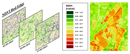
FAROS develops ‘stressmaps’ using automatic normalized difference vegetation index (NDVI) extraction. This index is useful in agriculture due to its ability to differentiate ‘stressed’ plants from healthy ones. It allows monitoring the vigour of crops to an exceptional detail, capturing their vegetative state and quantifying the photosynthetically active biomass.

NDVI values for fields enables farmers to know which areas of their fields need more work and fertilizer. The yellow shades show low biomass while the green high biomass.

Product Enquiry

Reviews

There are no reviews yet.

Be the first to review “FAROS”

Seller Information

  • Store Name: Iptsat
  • Seller: Valerio Caroselli
  • Address: Via Sallustiana 23
    00187
    ROMA
    Italy
  • No ratings found yet!


Other Categories